


![]()
The Te Araroa journey
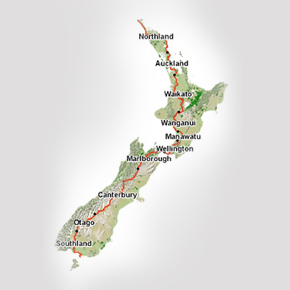
For anyone thinking about walking the Te Araroa Trail, either as a section walker looking to spread the experience over several years, or as a through walker planning to tackle the 3,000 km as one big adventure, my advice is to log on to the Te Araroa Trust website as your first port of call. They have heaps of useful and up-to-date track information, as well as excellent down loadable maps of the entire Te Araroa Trail.
Also read the many trip reports and walkers blogs that give a good insight into the conditions and experience of other walkers.
While finding your way is often very easy on the well marked sections on DOC track, some sort of navigation support is essential on the more remote parts of the Te Araroa Trail. Whether you are considering down loading the specialist TA maps or you plan to take your own mapping system, you will need to be able to navigate in poor weather conditions.
I carried a Garmin GPSMAP (62 series) fully loaded with the latest NZ Topo Map series and this was fantastic for keeping me on the trail, especially in difficult weather conditions like fog and low cloud. Without such navigational support you can quickly lose your bearings and walk right past a key bridge or hut.